IT This page is translated in English
This fourth issue of the third series (2012) of “Storia dell’Urbanistica” (“History of Town Planning”) describes the results of a basic research project initiated in 2010 involving numerous academics and scholars in the study of cadastres. Presenting a significant part of its results, the issue seeks to reinforce the necessity of firmly anchoring studies of settlement history and territorial transformation to thorough knowledge and understanding of governmental maps produced since the end of the 18th century. The project was stimulated by discussions regarding the preservation of Sardinia’s historic centers triggered by the 2006 approval of its Regional Landscape Plan (Regional Council approval n. 36/7, September 5, 2006).
The Sardinia landscape plan was the result of the provisions contained in Articles 135 and 143 of the national Code of Cultural and Landscape Heritage (on its cogency, please see the editorial in the journal’s 3/2011 issue) which specifically refers to the use of historic cartography as a means of recognizing the “centers of ancient and early formation” (Article 51 of the plan code), upon which to base the subsequent definition of their perimeters.
The research project – entitled “Development of methods for the production of medieval and modern reconstruction plans of cities in Sardinia: computerized analysis of lot structure and urban evolution of historic settlements” – was funded by the Regional Law 7 (August 2007, “Promotion of scientific research and technological innovation in Sardinia”) and coordinated by Marco Cadinu.[+]
It contributed to establishing and reinforcing important connections with comparable national and European initiatives, especially on the occasion of the international conference, “I catasti e la storia dei luoghi. Metodi per la ricostruzione storica di contesti urbani e paesaggistici, finalizzati alla tutela e al progetto” (Cadastres and the history of places. Methods for the historic reconstruction of urban and landscape contexts in preservation and planning) held in Cagliari on October, 12-13,2012.
The topic of historic cadastres highlights the journal’s continuing interest in exploring the relationships between documentary and archival studies and research on the formation and evolution of the historic city, even applied operationally to the fields of planning and preservation. Such relationships are supported by scientific principles deriving from other studies which, while distant in time, are still of indisputable actuality.
The most notable of these is Enrico Guidoni’s publication (1985-1992) of the first six maps (of the 86 planned) of the Rome Historic Center Map, with which the distinguished scholar sought to “contribute to the knowledge of the city’s architectural and urban heritage and its transformations, creating an initial framework of knowledge necessary for further research and investigation.”
The initiative consisted in layering contemporary cadastral mapping with Gregorian cadastre geometries (1816-1824) and archaeological information taken from Forma Urbis Romae by Rodolfo Lanciani (1893-1901). “Thanks to the immediate stratification of colors”, it sought to implement “an overall idea of the important pre-existing Roman context and the features of the built fabric before contemporary transformations.”
In 1985, this writer published the exhibition catalog for Città ed archivi nell’età degli imperi. Urbanistica e interventi di architettura da Napoleone agli Asburgo (1806-1866), (City and archives in the age of the empires. Urban and architectural interventions from Napoleon to the Habsburgs) held in Vicenza from September 27 to October 20.
The exhibition explored the formation of the French cadastre during the Kingdom of Italy period and the systematic introduction of graphic representation as a means to manage and govern urban design and architecture.
These pioneering initiatives were followed by the publication, promoted by Guidoni with the participation of other scholars, of the Atlante storico delle città italiane (Historic Atlas of Italian Towns) (initiated in 1985 and now with nearly fifty titles) in which cartographic restitution was considered the inevitable point of arrival for scholarly investigation.
This publication was accompanied by reconstruction plans of the urban fabrics of some Italian cities (Città della Pieve, Priverno, Vetralla, Blera, Tarquinia), which – as “manifestos” focusing mainly on the medieval period – included, in addition to the cataloguing of roads and key monuments, the census of walls that can still be observed through direct recognition or stratigraphic study.
These plans became the foundations for future studies and significant incentives for the preservation of architectural and environmental heritage. Still other experiences concerned the critical use of the information potential that could be garnered from 18th and 19th century cadastral maps: from medieval Modena (1999) to Renaissance Urbino (2002) to the 16th century plan of Senigallia (2009). The relevance and validity of the methodological foundations of Guidoni’s studies in this field were confirmed – after many years – by a number of recent initiatives designed to highlight and reinforce the knowledge contained in historic cadastral representations.
Among these, the Autonomous Province of Trento’s (2006) georeferencing of maps from the 1817 Austro-Hungarian land register is notable. In addition to representing lot boundaries, “with watercolors, conventional signs and symbols, differentiating the cultivations, building types, roads and waterways”, they display meticulous attention to detail as in the case of the “front entrance of a building highlighted in bold or [of] the grinding wheel that identifies hydraulically operated mills” rendering these maps “eloquent and understandable to non-experts”.
Yet another example is the constitution of a database (including approximately 13,000 maps and 35,000 pages of records) of the historic cadastres of Padua and Rovigo and an inventory of the Po Delta territory by the State Archives of Padua and Rovigo.
The on-line publication of this documentation (2013) required specific full text search software that could correlate information from different documentary and cartographic sources, allowing the navigation of cadastral maps and their relevant records, revealing the meaning of the symbols and numbering characterizing property divisions.
The project – entitled “Acque, Ambiente e territorio nelle terre del Delta Po e della Bonifica: valorizzazione ambientale e sistema informativo territoriale” (Water, Environment and Territory in the Po Delta Lands and Land Reclamation: Environmental Improvement and Geographic Information System) – was funded by CIPE deliberaton 20/2004; it was the first time that on-line consultation of historic cadastres (cartographic and documentary) of two entire provinces was made available on a national level.
It is worth noting, finally, the facsimile edition, edited by M. Repele, M. Rossi and E. Tonetti (Arzignano, 2011), the Instructions of the Central Directorate of Census surveyors responsible for the extent of land and formation of maps and sommarioni in performance of the Royal Decree of 13 April 1807, published in Milan in 1811, with which the Kingdom of Italy defines the rules (graphical and textual) for the preparation of cadastre, undertaken through the use of the Praetorian Tablet, geodetic instrument for some time been in the technical and conceptual baggage of surveyors, widely used for a few years before the military map of the Duchy of Venice (Topographisch-geometrische Kriegskarte von dem Hertzogtum, Venedig, 1798-1805).
The journal’s remarkable scholarly dedication manifested in this issue is attested by the number of truly outstanding papers and their organization in particularly interesting sections and thematic fields. Respecting its founder’s original intentions, “Storia dell’Urbanistica” intends to maintain its commitment – guaranteed by the resumption of its publication in 2009 – to remain the foremost reference point and forum for excellence in Italian and European urban historiography.
Indice
I catasti e la storia dei luoghi
Editoriale di Ugo Soragni 11-16
Introduzione di Marco Cadinu 17-19
CATASTI E DOCUMENTI PER LA RICOSTRUZIONE STORICA DEI LUOGHI
TAVOLE 1-26 20-46
Marco Cadinu
I catasti e la storia dei luoghi: un progetto di ricerca ancora aperto // Cadastres and the history of places: a still open research project 47-66
Elisabetta De Minicis
Riflessioni sull’uso dei Catasti storici per la conoscenza di un territorio in età medievale (tra topografia medievale e archeologia dei paesaggi) // Reflections on the use of historical Cadastres for gaining knowledge of an area during the medieval period (between medieval topography and landscape archeology) 67-76
Claudia Bonardi
Immagini e realtà delle forme insediative da catasti descrittivi e consegnamenti feudali di area subalpina (secc. XIV-XV) // Images and forms of dwelling in written cadasters and feudal “consegnamenti” in subalpine area (Fourteenth-Fifteenth century) 77-90
Gian Giacomo Ortu
Catasti e forme storiche della proprietà // Cadastres and historical forms of property 91-102
Teresa Colletta
I catasti storici del Mezzogiorno: dalle carte pre-catastali ai catasti post-unitari. Fonti privilegiate per la ricerca storico-urbanistica // Historic cadastres of ex Naples’ Kingdom untill the eighteenth century “ounce” based cadastre and the land registers of post-unification Italy. Sources for the history town planning research 103-122
Andrea Longhi
L’interpretazione dei catasti di età moderna per lo studio dell’insediamento alpino e pedemontano: l’esperienza di un progetto transfrontaliero // The interpretation of the modern era cadastral sources for the analysis of historical alpine and foothills settlements: the experience of a cross-border research project 123-138
Paolo Micalizzi
Descriptio Urbis. Un WebGIS per ricostruire l’assetto urbano di Roma // Descriptio Urbis. A WebGIS to reconstruct urban landscapes of Rome 139-150
Francesca Martorano
Catasto postunitario e GIS archeologico di Reggio Calabria // The Post-Unity Italian Cadaster and the Archeological GIS of Reggio Calabria 151-162
Paola Raggi
Planimetrie ricostruttive e rappresentazione dei centri storici delle Marche: l’esperienza di Urbino, Mondavio e Senigallia // Reconstructive plans and representation of historical centres in the Marche: the experience of Urbino, Mondavio and Senigallia 163-174
Laura Zanini
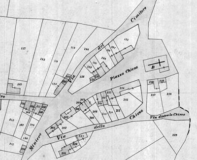
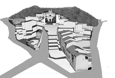
Confronti catastali e pianificazione: la ricerca dei “Centri Matrice” per i Piani Particolareggiati della Sardegna // Comparison of cadastral information and planning: the research of the “Historical Centers” and Detailed Implementation Plans in Sardinia 175-193
SCENARI URBANI
TAVOLE 27-77 194-246
Luisa Trinidade, Walter Rossa
Il sistema urbanistico della rua dos Francos (via dei Franchi) a Coimbra: evidenze e ipotesi, evoluzione e permanenza // The urbanistic system of Rua dos Francos [Coimbra]: evidences and hypotheses, evolution and permanence 247-260
José Luis Sáinz Guerra, Alicia Sáinz Esteban
Realización de planos de gran exactitud de las Villas Nuevas Medievales castellanas, análisis de las huellas de sus trazados en la cartografía actual. Aguilar de Campos, Peñaflor de Hornija, Tordehumos, Vertavillo y Herrera de Pisuerga // The drawing up of highly accurate plans of the Medieval Castilian New Towns: An analysis of the evidence of their layout in current cartography. Aguilar de Campos, Penaflor de Hornija, Tordehumos, Vertavillo, y Herrera de Pisuerga 261-276
Eva Chodejovska
Land Registers in the Czech Lands and their crucial role in studying the history of the landscape. Cadastral Maps as the sources of the Historic Towns Atlas of the Czech Republic and their place in the on-line GIS Portal of Prague Historical Cartography and Iconography // I catasti dell’area Ceca e il loro ruolo fondamentale nello studio del paesaggio. Le mappe catastali come fonte per l’Atlante delle Città Storiche della Repubblica Ceca e la costruzione del Portale GIS Cartografia e Iconografia Storica di Praga 277-288
Adam Nadolny
Utilization of historical maps and plans for protection and revitalization of Poznań at the beginning of 21st century // Utilizzo delle mappe e delle cartografie storiche per le azioni di salvaguardia e di rivitalizzazione della citta di Poznań all’inizio del XXI secolo 289-300
Marco Cadinu
I casalini e il progetto della città medievale // Casalini and the design of the medieval city 301-320
Roberta Rinaldi
Savigliano 1394: prove di mappatura dei dati catastali // Savigliano 1394: trials of cadastral maps 321-334
Cecilia Castiglioni
Torino alle soglie del catasto francese. Il contributo di Giovanni Lorenzo Amedeo Grossi (1753-1805) // Turin before the french cadastre. The work of Giovanni Lorenzo Amedeo Grossi (1753-1805) 335-344
Vittorio Defabiani
Uno strumento nuovo: il Catasto Rabbini (1855-1870) e la sua estensione parziale al Piemonte // A new Survey Instrument: Rabbini’s Cadastre (1855-1870) and its partial extension to Piedmont 345-360
Simona Pannuzi
I catasti dell’Ospedale della Consolazione a Roma: le case e la gestione dei beni // Cadastres of Consolation Hospital in Rome: the houses and asset management 361-380
Giada Lepri
L’evoluzione di un territorio suburbano tra la Via Salaria e la Via Nomentana attraverso lo studio dei Catasti dell’Archivio dei Canonici Lateranensi in Roma // The evolution of a suburban territory between the via Salaria and the Via Nomentana through the study of the cadastre from the Archive of San Pietro in Vincoli in Rome 381-396
Alessandro Camiz
La serie diacronica delle fonti notarili medievali e il mosaico catastale per il processo formativo di San Vito Romano // The diachronic series of medieval notarial sources and the modern cadastral mosaic for the formative process of urban fabric at San Vito Romano 397-412
Vincenzo Desiderio, Claudia Ornaghi, Roberta Tozzi
Chiusi della Verna e il suo territorio tra cartografia e iconografia // Chiusi della Verna and its territory between cartography and iconography 413-434
Federica Angelucci
I Cadastres e gli Ordnance Surveys inglesi come strumento conoscitivo per l’analisi e l’interpretazione delle trasformazioni urbane: il caso di Exeter (Devon, UK) // The Ordnance Surveys and English Cadastres as cognitive tools for the analysis and interpretation of urban transformations: the Exeter case (Devon, UK) 435-448
Maria Teresa Marsala
I riveli come possibile verifica nelle ricostruzioni urbane del primo Settecento siciliano: Avola // The riveli as possible verification in urban ricostruction of the early eighteenth century Sicilian Avola 449-468
Marco Cadinu
Un progetto di ricerca di base sulla documentazione cartografica, catastale e d’archivio per la redazione di cartografie ricostruttive delle città della Sardegna // A basic research project regarding cartographic, cadastral and archive documents for the preparation of reconstruction maps of cities in Sardinia 469-478
Vincenzo Bagnolo, Andrea Pirinu
Analisi della cartografia storica e catastale di Bosa. Le trasformazioni urbane in ambiente GIS // Analysis of historical cadastral maps of Bosa. Urban trasformation observed by GIS application 479-494
Marcello Schirru
Documentazione archivistica e materiali catastali per lo studio dei palazzi del Castello di Cagliari tra XVII e XIX secolo // Archival and cadastral documents for the study of palaces in the Castel of Cagliari between XVII and XIX century 495-508
Marco Cadinu, Andrea Pirinu, Marcello Schirru
Letture catastali, rilievi, e documenti per la lettura delle architetture e dell’urbanistica dell’area di Santa Croce del Castello di Cagliari // The Santa Croce area in Cagliari’s Castello neighbourhood: cadastral readings, surveys, and documents 509-543
SCENARI PAESAGGISTICI
TAVOLE 78-95 544-562
José Miguel Remolina Seivane
Catastro de Ensenada (1752). Un instrumento para el estudio de los espacios agrarios históricos en dos villas de Cantabria: Laredo y Santillana del Mar // Catastro de Ensenada (1752). An instrument for the study of the agrarian historical spaces in two towns of Cantabria: Laredo and Santillana del Mar 563-578
Alessandro Tosini
Il Liber Matricularum di Alessandria (1393): dalla descrizione medievale del territorio all’analisi del paesaggio storico // The Liber Matricularum of Alessandria (1393): from the medieval description of the territory to the analysis of the historical landscape 579-592
Chiara Devoti
Raffigurare un territorio anomalo: il Ducato d’Aosta tra catasto sardo non figurato e mappe francesi // To represent an anomalous area: the Duchy of Aosta between not figured Sardinian cadastral survey and French maps 593-606
Carla Benocci
Due catasti a confronto su terre di confine: il catasto gregoriano e il catasto leopoldino tra il Monte Amiata e Acquapendente // Two land registers comparison of borderlands: the Gregorian cadastre and the Leopoldino cadastre between Monte Amiata and Acquapendente 607-620
Nicoletta Giannini
L’organizzazione delle acque e dei mulini nei catasti urbani e rurali: il caso dei Colli Albani orientali (Provincia di Roma) // The organization of water and mills in urban and rural areas cadastres: the case of the eastern Alban Hills (Province of Rome) 621-634
Giancarlo Pastura
Cartografia e territorio: il catasto rustico dei terreni di Orte tra XV e XVI secolo // Cartography and territory: the Inventory of the grounds of Orte between XV and XVI century 635-640
Chiara Carloni, Giulia Maggiore
Analisi del territorio di Corneto (Tarquinia) in età medievale e moderna, fonti catastali e cartografiche a confronto // Analysis of the territory of Corneto (Tarquinia) in the medieval and modern ages, a comparison between cadastral and cartographic sources 641-652
Stefania Ricci
L’evoluzione del patrimonio arboreo di Castel Madama (Roma) attraverso la lettura dei catastali dal 1715 al 1854 // The evolution of the arboreal heritage of Castel Madama (Rome) through the reading of the cadastral from 1715 to 1854 653-655